At 5:40am on friday we arrived at Irvine Valley College and loaded up our cargo van full of tents, food, and other essentials. We loaded into 4 passenger vans and started the trek toward the valley around 7am. We charted the mileage at every turn or freeway change so that we could theoretically re-trace our steps at a later date. We had our first stop in Shoshone, a small small town with a population of 29. Yes, that's 29 people. This was a very nice place to have lunch, it was sunny and cool and the few cottonwoods and other trees around the buildings were dripping with Bullocks Orioles, Western Tanagers, Orange-crowned Warblers, White-crowned Sparrows, and two gorgeous male hummingbirds, an Allen's and a Black-chinned (made me wish I'd brought my good camera and lens instead of just the point and shoot). Also there were Say's Phoebes and some House Sparrows, yuck.

We stopped in Badwater, the lowest point in the continental U.S. as well as the Devil's Golfcourse which was a salt-crusted pockmarked landscape. Then onto Artist's Palette, which was an area where the volcanic rocks have reacted chemically to form gorgeous colors, which were then disjoined my faults running through the area which jumbled the colors together creating a color palette affect that gave the area its name.


We ended the first day at Furnace Creek Campgrounds where we made our home for the next two days. The next morning we stopped at the Visitor's Center to look around their museum and make some touist-y purchases. I bought a Mojave wildflower field guide which was very helpful for i.d.ing the few species of flowers growing this super-dry year.
From there we headed to Zabriskie Point which was an area where the Furnace Creek fault is no longer active. This spot was a good one to discuss the Furnace Creek and its flow patterns as well.

Off to Dante's View, the highest elevation we got to on the trip, it overlooks Badwater Basin, the lowest point. Here I saw Black-throated Sparrows foraging quietly on the hillside. Not much else was around as this spot was chilly and windy. From here we had a good view of the valley, as well as the highest peak in the Black Mountains, which was somewhere over 11,000ft, and considering Badwater is over 200ft below sea level, that creates quite a spread from valley floor to peak.

Next was the ghost town of Rhyolite. A cool place to see old buildings, as well as some nifty wildlife. It was here I spotted the Black-tailed Jackrabbits, as well as more Black-throated Sparrows, and Gambel's Quail. The town was named for the stone, rhyolite which was all around the area.

We headed to Titus Canyon, which was a very gravely, unpaved drive down into a valley, up a winding hillside, and down into the Titus Canyon area. I covered my eyes for portions of the steep drive, but other spots the scenery was distracting. This was the location of nearly all the wildflowers I saw over the course of the trip, as well as some of the most useful geologic actions. The synclines and anticlines seen here really helped cement the concepts into my brain for my geology final coming up in a few weeks. It was nice to put the real life images to the descriptions we had learned in class.

We ended the day standing over the active portion of the Furnace Creek fault, which was a neat strike-slip fault covered in young desert pavement. The winds really picked up Saturday night, making sleep quite difficult, so everyone was a bit groggy and cranky the next day.
Sunday morning we started at Salt Creek, which is the area where the Desert Pupfish are found. The water in the creek is as salty as seawater and has basically no other life within it, cool.
Next was the sand dunes, which ended up being my favorite part of the trip, these warm, soft, sandy rolling hills were fun to walk around, and completely full of wildlife. I saw lizards, a scorpion(!), and a sparrow that I wasn't able to identify since I had left my bins in the van and it was not being incredibly cooperative =(


We paused briefly at the Devil's Cornfield where we saw how blowout had taken away the sand at the roots of the plants, leaving the plants sitting high on their exposed roots, which gave them the appearance of corn fields.

Our last stop was in Trona at the Pinnacles to eat lunch. The Pinnacles themselves were very cool looking (some parts of Star Wars were filmed there) but the wind was blowing incredibly hard, which made eating, and even walking outside, very difficult. We chose to stay in the van except to slip out and take a few pictures and use the restroom.

From there we drove the last leg of the trip through the Cajon Pass and home! All in all it was a wonderful trip, I really enjoyed getting to see the aspects of geology we'd been studying for the last few months in living color. It helped bring the concepts to life and make it easier to see how they fit together.
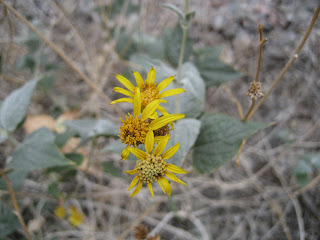
My wildflowers from Titus Canyon:


3 comments:
Sounds like a fantastic trip, Leigh. that terrain is unearthly!
Very cool, Leigh. Thanks for the virtual tour.
=)
Post a Comment